


North Augusta #25 Voting District, Aiken County, South Carolina
About
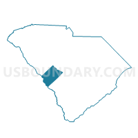
Outline

Summary
| Unique Area Identifier | 664895 |
| Name | North Augusta #25 Voting District |
| County | Aiken County |
| State | South Carolina |
| Area (square miles) | 1.68 |
| Land Area (square miles) | 1.57 |
| Water Area (square miles) | 0.11 |
| % of Land Area | 93.68 |
| % of Water Area | 6.32 |
| Latitude of the Internal Point | 33.48746970 |
| Longtitude of the Internal Point | -81.96267710 |
Maps


Graphs
Select a template below for downloading or customizing gragh for North Augusta #25 Voting District, Aiken County, South Carolina


Neighbors
Neighoring Voting District (by Name) Neighboring Voting District on the Map
- 245102 - 102 Voting District, Richmond County, GA
- 245112 - 112 Voting District, Richmond County, GA
- Carolina Heights Voting District, Aiken County, SC
- North Augusta #26 Voting District, Aiken County, SC
- North Augusta #29 Voting District, Aiken County, SC
- North Augusta #54 Voting District, Aiken County, SC
- North Augusta #55 Voting District, Aiken County, SC
Top 10 Neighboring County Subdivision (by Population) Neighboring County Subdivision on the Map
- Augusta CCD, Richmond County, GA (134,777)
- North Augusta CCD, Aiken County, SC (54,044)
- Beech Island CCD, Aiken County, SC (8,312)
Top 10 Neighboring Place (by Population) Neighboring Place on the Map
- Augusta-Richmond County consolidated government (balance), GA (195,844)
- North Augusta city, SC (21,348)
Top 10 Neighboring Unified School District (by Population) Neighboring Unified School District on the Map
Top 10 Neighboring State Legislative District Lower Chamber (by Population) Neighboring State Legislative District Lower Chamber on the Map
- State House District 121, GA (39,901)
- State House District 84, SC (36,703)
- State House District 83, SC (36,663)
Top 10 Neighboring State Legislative District Upper Chamber (by Population) Neighboring State Legislative District Upper Chamber on the Map
Top 10 Neighboring 111th Congressional District (by Population) Neighboring 111th Congressional District on the Map
Top 10 Neighboring Census Tract (by Population) Neighboring Census Tract on the Map
- Census Tract 209.02, Aiken County, SC (5,994)
- Census Tract 207.01, Aiken County, SC (5,583)
- Census Tract 208.02, Aiken County, SC (5,010)
- Census Tract 207.02, Aiken County, SC (4,993)
- Census Tract 6, Richmond County, GA (2,890)
- Census Tract 110, Richmond County, GA (1,668)